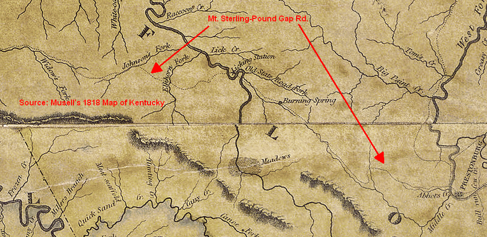
The 1818 Munsel map of Kentucky shows a number of early roads. Some of them were designated "State Roads". One of particular interest ran between Mt. Sterling and Prestonburg, on through Pine Moutain's Pound Gap (Sounding Gap) to Virginia. Some maps also refer to this road as "Indian Vall". It was more commonly known as the Mt. Sterling-Pound Gap Road. Prior to the Civil War, the Mt. Sterling-Pound Gap Road was eastern Kentucky's main highway.
Before settlers arrived it was one of many trails crossing and entering
Kentucky that were used by Native Americans on their hunting
expeditions. It may very well have been formed even earlier by the huge
herds of bison moving back and forth through the wilderness.
The road entered what is now Magoffin County at the west side following
Johnson's Fork a few miles before reaching the Licking River at Licking
Station, then following the Licking on to Burning Spring and on east to
Prestonburg. From there it followed the Levisa Fork of the Big Sandy
into Virginia.
Pound Gap was used by explorers as early as 1750, and even Daniel Boone
in 1774, but it was 1798 before pioneer families started using this
route into eastern Kentucky from Virginia. Soon it became a trade route
for Kentuckians taking their livestock to Virginia markets.
The Mt. Sterling-Pound Gap Road is of particular
importance to Magoffin County, because many of the earliest settlers to
the area came down this road eastward from more established settlements
in central Kentucky, including Archibald Prater and the settlers who
attempted to settle near Salyersville in 1794. At that time, the land
east of the Licking River was part of Mason County, while the land west
of the Licking was part of Bourbon County.